
Engineering the data layers that power Climate action.
We aggregate, clean, and integrate climate data from satellites, sensors, and other sources, converting complex datasets into reliable visualizations, analytics, and public data platforms.
Our Live Environments Hub
We synthesize chaotic climate data into precise, public-facing intelligence consoles.
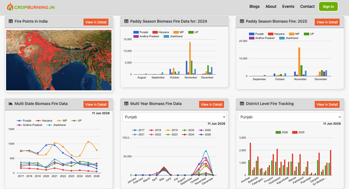
CropBurning.in
An advanced multi-spectral spatial platform mapping real-time open agricultural fires and active seasonal anomalies across the subcontinent. Armed with high-resolution satellite arrays, it delivers automated thermal tracking coordinates and predictive smoke dispersion paths directly to institutional dashboards.
Fires Detected (2026)
Automated thermal alerts collected via multi-spectral satellite arrays.
Tracking Layers
Monitoring heat intensity, smoke paths, and fire spread.
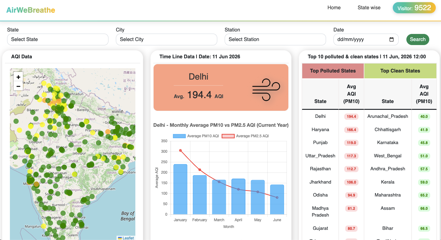
AirWeBreathe.org
A highly granular environmental telemetry engine delivering real-time particulate indices directly down to localized municipal grids. The architecture aggregates hyper-local sensor inputs to surface immediate health risk alerts across densified urban centers.
Severe respiratory stress. Triggers elevated vascular inflammation and hyper-acute asthmatic fatigue.
Carbon Trace Pipeline
Tracking industrial combustion profiles & biomass patterns.
Solar Trace Pipeline
Tracking solar power generation patterns.
Built for quick integration into websites and apps.
Need data fields for a student project or custom company dashboard? Our files are kept lightweight so you can retrieve formatted files via standard internet links instantly without sorting messy raw data dumps.
{
    "status": "successful",
    "total_results": 1,
    "data": [
        {
        "state": "PUNJAB",
        "district": Patiala,
        "year": 2026,
        "fire_count": 1139,
        }
    ]
}
The Climate Mesh Framework
Unifying independent data science with high-resolution environmental computing to map global emissions with unparalleled clarity.

About Our Mission
We accelerate measurable climate action by mobilizing a national tech collective to index greenhouse gas data with radical speed, providing clear inventories to the global public.

Ecosystem Data Pipeline
Industrial emissions activities shouldn't happen in the dark. We cross-reference multi-spectral satellites, localized remote sensing, and custom machine learning modules to build real-time monitoring records.

Partnership & Collaborations
Expand our global data coverage. Whether you are an open-source engineer submitting optimization patches, a research center sharing dataset packages, or a platform developer accessing our APIs, get in touch.
Our Core Services
We bridge the gap between heavy academic earth science files and modern, working web applications.
Data Libraries & Live Feeds
We gather, organize, and sort tricky environment data into reliable databases. Our systems let companies and research teams view or pull this data in seconds, making it incredibly easy to connect accurate climate metrics directly into your own tools.
- ✔ Automatic Mapping: Generates clean, visible maps out of spatial numbers.
- ✔ Easy Carbon Rules: Makes it simple to see emissions and smoke charts.
- ✔ Safe Data Paths: Protects all your file downloads with modern encryption.
Custom Green Tech Software
We build custom, reliable websites and web software designed specifically for green energy and community projects. Using our eight years of professional software experience, we create secure dashboards, interactive geospatial mapping tools, and systems for multi-user teams.
- ✔ Live Dashboards: Refreshes your screen info automatically without loading delays.
- ✔ Data Pipelines: Integrates external API feeds, satellite layers, and public climate streams seamlessly.
- ✔ Secure User Logins: Sets up clear roles for admins, teachers, clients, or team members.
Connect With Us
Whether you are a company looking for regular data feeds, a researcher wanting raw spreadsheets, or an NGO needing a custom tracking dashboard—let's work together.